German Archive Privacy Laws

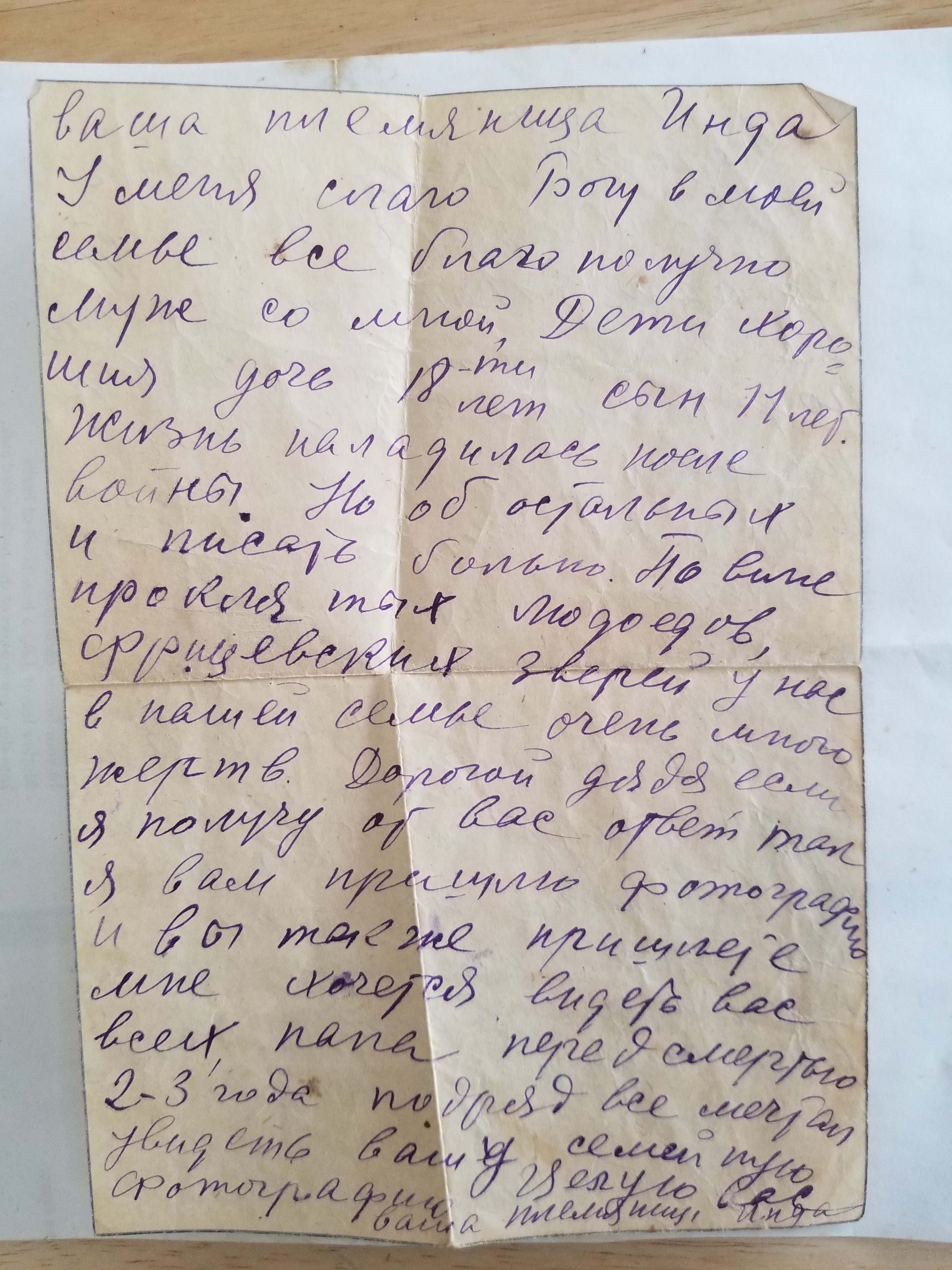
German privacy laws are no joke. For the past two weeks, I have been doing archival research in Freiburg and Berlin. In all of the archives in which I have worked (so far five), I have had to sign paperwork that says I will protect the personal information of subjects whose identities I come across in my research. I do not have a problem with this, but today I was in for quite a surprise in the East German division of the German Federal Archive (BA-SAPMO). When I registered online and checked in yesterday, I had to sign release forms about the protection of personal information for specific archival collections. Today, as I was sitting in the reading room and working through a series of documents that I could not photograph (ah, the feeling of Russian archives) due to their personal nature, an employee came up to me and told me that he needed to speak to me about my research topic. He led me into a back room and then began to interrogate me about my research topic in depth and what I was hoping to find in the documents that I had requested. He then asked about my university and said that he would need to keep a photocopy of my university ID in the archive records.

This, oddly, was a moment that felt like being back in Russian archives. I was actually surprised that all I had to do to register for the German archives was to email and fill out some forms online. In each reading room all I had to do was tell the staff my name and they would give me my files. In Russia, however, the archive registration process is far more strict. To apply to work in Russian archives, one need to present a signed letter (an отношение) that explains your topic, the dates of study, and your university affiliation. The letter has to be on university letterhead and a signature of the highest possible academic rank is best, that is it is better for it to be signed by a dean than a professor. When questioned about my research, the archive employee asked me about my university affiliation. He asked if I had a letter about it, and I had a minor deer in the headlights look as I said no, had bad flashbacks to Russia, and stated that I had my student ID. He said that would suffice.

Before I could get my files, I had to assure the staff member that I would anonymize any personal information that I found in the records I was perusing. When my dissertation is complete, I also need to submit a copy to the Federal Archive so that they can have it on record. My ID and answers were sufficient, and I was granted access to the remaining folders that I had requested, or rather had requested for me. The excellent take away from German archives is that the staff is very helpful. I emailed the archive’s general email account in May when I was planning my trip. My topic was given to some archivists, who put together a 20-page packet that listed all of the files that I should consult. Upon my arrival to this particular archive yesterday, I was handed sheets of paper for additional files that I should consult. At the time, one staff member handed me the privacy forms to fill out and proceeded to order 14 files for me without me knowing what exactly was in them. Thankfully, it was useful information.

Soviet Military Maps

Do you like Cold War era espionage and intrigue? How about mapping and historical geography? Are you a fan of James Bond films? Care to pretend like you are in one? Well, boy do I have the resources for you to realize these fantasies. Two Christmases ago, I was having coffee with a childhood friend, who told me that he had purchased his mother some declassified Soviet military maps for Christmas. This reminded me of an article that I had been sent by a different friend from Wired. Basically, the Soviets engaged in a large-scale map making project for the entire world. A cache of these maps had been discovered in the former Baltic republics of the Soviet Union. Enterprising locals, some of whom had a fair amount of disdain towards the Russian government, realized that they could make money selling off these former top-secret military resources.

I’m not sure how my friend came across them, but he did and purchased a few original maps as well as a few reproductions through eBay. The original maps are in wonderful quality, the reproductions not so much. We had coffee and I translated the map key for him. Fast forward to about a month ago, another good friend showed me a review of a book called The Red Atlas, authored in part by one of the subjects of the Wired article, John Davies. It’s the first book to examine the Soviet military maps in depth. I altered my friend to the book, and he in turn gave me the information for the eBay store from which he purchased his maps.

Being a bit of a mapping nerd these days, I was ecstatic to see that there was a Soviet military map for Boston, its surrounding area, and the Atlantic Ocean. At only $25, I felt compelled to buy the map. Mostly I wanted it for the map of Cape Cod, where I spend most of my time when not required to be at school or gallivanting around Russia. It only cost $5 for shipping from Latvia, and the package arrived four days after I ordered it.

I got a map from Latvia in four days. It took 2 months to receive a letter from the USA in Moscow.

Upon opening the map, I was extremely happy to see the level of detail that the Soviets had put into the map. Chatham Light House was there, as is CQX, the tiny municipal airport that can only service propeller planes. Naturally, the Hyannis Airport was on the map, as is Camp Edwards and its Otis Air Force Base.

Cape Cod as mapped by the Soviets in 1986

Luckily for me, my university library had just ordered a copy of Red Atlas, which I was happy to check out. The book itself is a Soviet history nerd’s dream. The cover states совершенно секретно (sovershenno sekretno, top secret). The majority of my archival sources were generally stamped with this, so it’s a phrase that I’m always interested to see. Indeed, as Davies and Kent note in their book, there were different maps, which had different scales, details, and levels of secrecy. Thankfully, this book includes handy keys to decipher the military maps. Using the key with my Boston map, I’m able to discern quite a lot more from the map than just how the Soviets tactically analyzed the area from which I come.

So most of my map of Boston happens to be the Atlantic Ocean. You have to know where to sail the submarine if you want to avoid the plot of “The Russians Are Coming, The Russians Are Coming.”

Knowing Russian, I am able to read from the map that is from the 1986 iteration of mapping, though the map itself was printed in 1993. With a quick Yandex (the Russian Google) search, I was able to decipher the acronyms of the publisher. The map says that it was published by the Military Topographic Directorate of the General Staff with the original information from the Main Directorate of Geodesy and Cartography of the Council of Ministers of the USSR. I know that the scale is 1:1,000,000. According to Red Atlas, this means that my map was a small-scale/general terrain evaluation map, which was an unclassified map. The book also gives me a better understanding of where the map was printed. My particular map was printed in December 1993 with a factory code of И (or I) for Irkutsk, a major city in Siberia.

TL;DR – Soviet military maps are cool. You can buy them online, and there’s a nifty book that explains the maps and the massive efforts it took to produce them, an undertaking that was and still is shrouded in mystery.

Digital Mapping and Family History

It’s a new year and I’ve got a cool HASTAC Fellowship, so I’ve decided to add a blog component to my website to occasionally write about cool stuff related to my research, digital humanities, and mapping. I’ll be kicking this all off with a somewhat personal post. Those who have followed my personal travel blog from Russia might know of my brush with fate and how I was able to reconnect with part of my family that we hadn’t really been in contact with since my grandmother, her sisters, and her parents were evacuated by the British during the Russian Civil War. At least one member of my grandmother’s mother’s family remained in Simferopol, Crimea, and became a known Soviet poet, one who was the first to witness and write about the Holocaust. There’s actually a fantastic book written about him. I last saw his daughter in Moscow in July and again in October of 2017.

After my grandmother, her parents, and her sister came to America, my great-uncle was born. He passed away about a year ago and my father brought us some of the pictures and letters, which he had kept from his parents. It seems that my grandmother’s father’s family remained around present-day Ukraine. Some stayed in Kiev, others in Berdichev. Being a historian and the only living member of the family that speaks Russian, I was intrigued to look at the photos and letters. However, it soon became apparent that my knowledge of the history would become depressing.

One of the items that was most shocking was a photograph of the extended family. The bottom of the photo has a caption saying that Isaac was killed at the factory. The back of the photo, though, was much more troubling. It says that it was taken in Berdichev in 1923. Upon reading that, I immediately had a pit in my stomach. Berdichev was one of the major sites of the Holocaust, where the majority of the city’s Jewish population was exterminated. It is highly likely that all of those pictured perished.

A subsequent letter from 1948 between my great-grandparents and one relative from Kiev alludes to the toughness of the war. The author, Inda, notes that she had received a letter two years before, and only just found the time to write back. She states that her family was doing much better after the war, but that “it is painful to write about the others” and that “due to the officer beasts, many in the family perished.” Most in the Western world don’t understand the toll of the Second World War on the Soviet Union. 27 million Soviet citizens perished during the war, 2 million of whom were Jews in the Holocaust. It is not an exaggeration to say that every Soviet family was touched by the war and lost at least one person. While I had suspected some of this, I had never known the extent. Indeed, my own extended family suffered losses during the war.

This brings me to my connection between my personal life and my research. For the past few years, I have worked as a teaching assistant for a course on genocide and weapons of mass destruction. One year, we read Father Patrick DesBois’s The Holocaust By Bullets, which chronicles the Holocaust in Eastern Europe, primarily in the territory of the Soviet Union, beyond the major deathcamps such as Auschwitz or Treblinka. Unlike at those camps, where killing was mechanized and impersonal, the vast majority of the executions in Soviet territories was by cruder, personal means such as shootings. Berdichev was one of these sites. While using Father DesBois’s book, I found out about his interactive mapping project, as I was embarking upon my own work with German prisoner of war camps. I consider Father DesBois’s map of the Holocaust by Bullets to be one of the best interactive mapping projects I have ever come across. In addition to plotting the extermination sites, each location features information from relevant archival sources, either German or Soviet, as well as testimonies from those who remained. Anyone interested in historical GIS, digital humanities, the Holocaust, or the history of World War II should know of this resource. This mapping project quickly and easily conveys the magnitude of the exterminations. It also readily illustrates the human toll of the Second World War on the Eastern Front. More work of a similar nature should be done to visualize the economic and human destruction of the Second World War.

css.php